Sandy Hook to New York City:
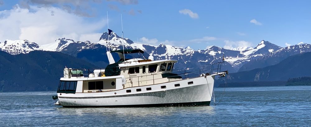
We have spent the last five days at the anchorage in Atlantic Highlands Harbor which is just inside the tip of Sandy Hook, NJ. There have been some spectacular sunsets each evening.
The New York skyline is just eight miles north of us across the bay. We have stopped here several times before but have never had the chance to really explore the area. The town of Atlantic Highlands is a small bedroom community for those working in NYC. Each day many high speed ferries zoom back and forth carrying passengers into the Big Apple. The harbor is extremely active with many private boats as well as a large fleet of charter fishing boats. The local yacht club offers a launch service for the many sailboats moored in the harbor.
We decide to put the dinghy down to explore the town. As Jeff first runs Time Out around the harbor, he quickly discovers that he has no steering. This is the first time in three months that we have used the dinghy. The steering has frozen up from lack of use. Luckily, he wasn’t too far from the boat and is able to paddle back. After several hours of work, the steering is finally freed up.
Sebastian tells Dad “that is what you get for not taking us to shore”. We are now ready to go. Downtown we find a wonderful bagel shop which we frequent each morning. The one main street is filled with a wide selection of local restaurants, a well stocked hardware store, several small variety stores, and a marine supply store. We enjoy a great lunch at the local diner. Our next stop was to the post office to pick up our weekly mail drop.
Since we were here in October, the town has added a two mile running/bike path which connects to the town of Highlands. It is apparently very popular with the locals as from our anchorage we watch a constant stream of walkers and bikers going back and forth. We finally get the bikes down and join in.
After reaching the town of Highlands, we continue across the small bridge to the Gateway National Recreation Area which is a national park encompassing the Sandy Hook coastal area. The sandy beach dunes stretch for several miles along the bike trail.
The National Park houses the Sandy Hook Lighthouse which is the oldest working lighthouse in the country.
Fort Hancock, a former military base, is also within the park. Here we bike along WWII ammunition bunkers, firing ranges, weapon storage areas, and testing ranges for the army.
The bicycle trails intertwine with many hiking trails through this coastal dune area. We return back to the boat after 25 miles of some wonderful bike riding.
Each afternoon we watch to see what new transient boats will anchor in the harbor. We keep an eye out for people anchoring too close to us. On several nights we are awoke during the night with 20-30 knot winds and thunderstorms. We are glad to be behind the protected breakwater of the anchorage. We take turns keeping watch to make sure our anchor does not drag and more importantly that someone else does not drag into us. One evening a barge and crane enter the harbor and head our way. Surely they are not anchoring in here with us. They push the barge up to 100 yards of our boat. As we watch the crane raise and drop the bow and stern piling into the sand, it becomes apparent that they are anchoring here for the night. After securing the barge, the two workers motor off in their little tug leaving the barge alone with us.
We have never had a barge anchor beside us before. This is a first. It is secure with those two huge pilings and never budges.
The time arrives for us to move from our anchorage at Sandy Hook over to Liberty Landing Marina just across the Hudson River from Manhattan. We will stay at the marina for one week while we become tourist in NYC. The weather is absolutely awful today. Luckily we only have a short run through NY harbor to the marina. As we pull up the anchor it is pouring down rain. My job is to stand out on the bow and wash all the mud off the anchor chain as Jeff remotely retrieves it from his nice warm dry spot in the pilot house. Half of my spray from the hose is blown back onto me from these high winds. Between the rain and hose spray I am completely drenched by the time the anchor is retrieved.
Today we are not interested in the sights as we pass under the Verrazano Narrows Bridge and then past the Statue of Liberty.
It is cold and pouring down rain with limited visibility. We keep our eyes on the fast ferries that zoom back and forth across the waterway. We stay out of the main channel as much as possible and travel through the anchorage area for the big barges. The fast ferries don’t come through this area. As we reach the Battery, we must cross the busy traffic channel to reach the New Jersey shore. We wait while the two big Staten Island ferries cross just in front of us.
As we enter the canal for Liberty Landing Marina I radio them on the VHF for directions. After several attempts there is still no answer. Finally another boater radios us and says to call on channel 72. Normally the procedure is to call on channel 16 and then switch to a working channel. I guess they do things different here. The dockhand immediately answers our call on channel 72 and gives us directions to our slip. We weave our way past almost every other boat in the marina to get into our tiny spot. It is windy and raining and now we have to wedge our big fat boat into a slip that looks almost impossible to fit into. Somehow Jeff manages to get IT in without touching anything. I think they put us here because it is close to the office and that way the dockhands didn’t have far to go in this rain to help us in. There are a lot of vacant slips which would have been much easier for us to get into.
Our marina is on the New Jersey side and is part of Liberty State Park. We can see the Statue of Liberty from our boat. Downtown Manhattan is just across the Hudson River.
There is a cute little water taxi that stops at our marina every 30 minutes for the trip to NYC.
This seems like a great spot for our week of visiting NYC.
Total Miles Sandy Hook, NJ to Liberty Landing: 21
Total Miles Traveled Year to Date: 1597
Cape May to Sandy Hook, NJ:
Our next leg from Cape May to Sandy Hook requires an offshore passage up the New Jersey Coast. It is just too shallow for us to take the inside route on this next section of waterway. We end up staying in Cape May for six days waiting for the wind and seas to calm down. This really is not too bad as Cape May is a nice town to visit. Plus we are really just killing time now as our reservation in NY City doesn’t start for 10 more days. Once the weather improves we will move up the coast to Sandy Hook and anchor there until we go into the city. We are not in a rush.
Just across from Utsch’s Marina is The Lobster House Restaurant.
Tourists come from miles around to eat at this famous establishment. They even have their own fishing fleet docked just behind the restaurant.
Being a holiday weekend, the wait time at the restaurant was two hours so we decided to do a take out from their fish market. The food was O.K. but I think it is more of a tourist trap than anything now. We saw several other loopers here at the marina also. “Pookie II” invited us to breakfast one morning at the local dinner just across the street. We first meet Evan and Pookie while doing the Dismal Swamp. It turns out they are from Pulaski, TN. I am sure we will see them many more times along the loop.
We enjoyed several pretty walks into town with the dogs.
It is about a two mile walk into town but the time goes quickly as we marvel at the large Victorian period houses lining both sides of the streets.
Nestled between these stately mansions we find small gingerbread cottages with ornate trim all brightly painted.
One day we discover a small dog park on our walk. Daisy and Sebastian really appreciated this find. Downtown there is a nice pedestrian mall with many small tourist shops for us to visit.
The winds continue to blow for several days gusting up to 30 knots. The seas are 7-10 foot out in the ocean. We aren’t going anywhere for a while. This gives us a chance to catch up on some boat chores and also do some planning for the Great Lake section of our trip. Even though we navigate with our electronic charts, we always update our position on the paper charts also. In checking our paper charts we discover that there are still several charts which we will need as we go north. It is mind boggling how many charts and cruise guides are needed for the loop.
Several boats on a tight schedule leave during these windy days. I wouldn’t want to be out there if I was them, but they are in a hurry. A Nordhavn, “Uno Mass”, decided to make an overnight run as the seas are usually calmer at night. We briefly spoke with these folks before they left as they saw we were from TN and were asking about cruising the TN River. They want to do that trip next year. We think of them several times during the evening as the winds and seas continue to build and the fog rolls in reducing visibility to near zero. I don’t think they are having a good evening but they are experienced cruisers. They were participants in the North Atlantic Rally several years ago in which a group of boats crossed the Atlantic Ocean. They were the smallest participant with their 40 foot Nordhavn. After four days, we decide to move from the marina out to an anchorage. The anchorage is located next to the Coast Guard station just off the main channel for the Cape May harbor.
This spot is not ideal as we continue to get rocked by the boats as they come and go through the harbor. We do however enjoy watching all of the boat traffic, especially all of the Coast Guard ships as they practice their maneuvers each day.
The winds and seas finally die down after two days at anchor and we give it a go up the Jersey Coast. We leave the Cape May Inlet at first light. It will be a long day and we want to arrive to Sandy Hook before dark. The ocean seems fairly gentle today. We have some three to four foot swells but they are pretty far apart. IT goes up and over each one with ease. Before too long, we see all of the casinos along the Atlantic City Boardwalk off in the distance.
We will bypass these on this trip.
There are lots of small boats out today fishing. It is a Sunday and all the locals are taking advantage of this nice weather. We get some good practice with our new ARPA radar program as we locks in on all these boats with the ARPA. It quickly tells us which the heading and speed of each target along with closest point of approach. IT is running great and we have an uneventful day up the Jersey coast.
The New York skyline rises into view as we approach Sandy Hook. As we are gazing off in the distance at the city, something catches my eye as it jumps out of the water. I tell Jeff that I think it was a whale. We both really doubt that as we are only 1 mile offshore in only 40 feet of water and have heard no reports of whales being in this area. A few minutes later we both see a 40 foot whale rise majestically straight up from the beneath the ocean surface. He seems to be in slow motion as he breaches just 50 feet from our boat. WOW!! We can see his huge white throat pouch filled with his daily catch and his large white pectoral fins as he gracefully rolls over to swallow his meal. It really took us both by surprise and I missed the million dollar picture of him half way out of the water. It is a moment we will not forget. We soon see a second whale feeding nearby.
We slow to idle speed as the whales continue to feed just feet from our boat. We determine that there are at least three Humpback Whales.
Jeff calls the Coast Guard and alerts them to the whales’ position. Although we would like to stay and watch, we must push on to reach our anchorage before darkness sets in. Who would have thought that we would see whales this close to NY City.
We arrive to our anchorage just as the sun touches the horizon. It was a good day!!
Total Miles Traveled Cape May to Sandy Hook, NJ: 131
Total Miles Traveled Year to Date: 1576
Sebastians’s Story #8:
Hey gang. It’s been a long time since I have given ya’ll an update. Capt. Dad said that I was long overdue as the Cruise Director (CD) and have neglected reporting on the activities aboard Idyll Time (IT). We certainly have been busy since coming back aboard earlier this month.
The first thing to tell about is all the dogs we have met this spring while traveling from St. Augustine, FL to New York. In Great Bridge, VA, Daisy and I met a dog that could have been Daisy’s twin.
For a short time there I thought I was seeing double. Her name was Truffles. She was a four year old Sheltie and lives aboard like we do. She had a 16 year old brother, Poppy, a Sheltie also. I was surrounded by Shelties.
One per household is my rule. While traveling the Great Dismal Swamp, we rafted up with 10 other trawlers and sailboats. It was really strange having all these people walk through our boat to get ashore. Almost every boat had a dog or cat. It was great to meet them all. The cat next to us, Mikey, was a Maine Coon cat and he weighed 19 lbs, the same as me. Boy he was a big cat!!
His big bushy tail and thick coat made him seem twice as big. Everyone was so friendly and I got lots of dog treats from the other boaters. Hey, I think I like this rafting thing.
A common question we get is how we manage our bathroom duties aboard IT. Admiral Mom bought us a new mat especially made for this necessary task. Capt. Dad added some small plastic palm trees for me in one corner. Daisy and I have become quite proficient now, especially since we get a treat after using our new mat. It is not the real stuff but I guess we can make do.
It has been getting cooler the further north we travel. Earlier this month, Florida was nice and warm. Too bad we couldn’t stay but we have to be in NY City on June 8th to meet niece Courtney and nephew Stormy. They will be aboard with us for 10 days. After visiting NYC for three days, we plan on going up the Hudson River to begin our trip through the Erie Canal to the Great Lakes and Canada. We had a great time with the kids earlier this spring in Florida. I got lots of petting and attention from both of them. They have a dog at home so they are “Dog People”. Stormy and I got along especially well. Courtney let me sneak up into her bed and under the covers. I like traveling with these two. They both will fly home to Chattanooga with Capt. Dad from Albany, NY. As the CD, making all these travel plans keep me quite busy. I’m not too sure about visiting Canada this summer. As you know, I prefer the warmer climates. Isn’t Canada cool in the summer? I need to talk with Admiral Mom about this. Maybe she could buy me a new jacket. A CD should always be tan, well fed, and warm.
Later,
Sebastian
Great Bridge, VA to Cape May, NJ:
After four days of being holed up in Great Bridge due to high winds and rain, it finally looks like the weather is starting to improve. We are getting cabin fever after being here so long. From Great Bridge we have a short but tiring day as we work our way through the Great Bridge Lock and then the maze of bridges on this section of the waterway on our way to Norfolk, VA. The scenery is now filled with industrial buildings and huge ships.
Massive container ships from all over the world travel up this ship channel.
Navy war craft of all types fill dock after dock. We seem like just a small dot compared to these huge vessels.
Just before Norfolk, we reach mile 0 of the Intracoastal Waterway (ICW). This inland waterway runs from here all the way to Key West. We are happy to have the ICW now behind us. We stop for the evening after only 25 miles at an anchorage just outside Norfolk at Old Point Comfort. The next morning we pull anchor just as the sun is rising for our long run to Solomons, MD.
We have a perfect day on the bay as it is mirror smooth as a lake out today. As we pass Reedville, we see the big Menhaden fishing fleet working the schools of Menhaden in the deeper sections of the bay. We have a calm day on the water and are to Solomons by 4:30 PM. We quickly gather up the dogs and go for a much needed run around the familiar surroundings of Calvert Marina.
While in Solomons, we are docked just in front of the impressive trawler “Spirit of Zopilote”.
We first saw this 68 foot yacht motoring past us while we were tied up in Great Bridge. Jeff was lusting after her as she went by us. She is everything one would want for an ocean passage trawler. We are soon introduced to her owners, Bruce Kessler and Joan Freeman. Bruce later gives us a tour of this fine ship. It turns out that there is an interesting history for both the owners and the boat. Bruce Kessler is well know in the trawler world for his around the world voyage in the 90’s on his previous yacht “Zopilote” which was 10 feet larger than the current “Spirit of Zopilote”. He was the first person to complete this around the world voyage in a trawler of this type. After successfully completing this circumnavigation, while cruising in Alaska, “Zopilote” hit an uncharted rock and sank within minutes. They have since designed and custom built their current yacht “Spirit of Zopilote”. Bruce Kessler’s life before the around the world adventure is equally impressive. He was a world class race car driver and later a well respected Hollywood film director. Some of the TV programs he directed were The Monkeys, Mission Impossible, Marcus Welby MD, Touched by an Angel, and the A-Team, among many others. His wife, Joan Freeman, is a famous movie actress. She stared with Elvis Presley as one of his girlfriends and also was one of the mom’s on Lassie. They both now live on their trawler and are cruising to Maine for the summer. They seemed like down to earth people and were very friendly. Unlike some people on big yachts, they have no crew. They operate the boat with just the two of them. We would see them out waxing and polishing the boat each day, no different than what we were doing.
While in Solomons, we are treated each afternoon with a front row seat to the fly over’s of the Blue Angels while they are practicing for an upcoming air show here this weekend.
We watch in awe each afternoon as they buzz low overhead.
An extra day was spent in Solomons after Jeff found out about a new electronics gadget which could be added to our radar system. Bruce, our electronics guru and good friend, from Bristol Technologies told Jeff about ARPA. With this addition to our RADAR we can now gain more information on any targets which it locates. In addition to showing these targets on the radar, ARPA will automatically track and monitor up to 10 radar targets at a time and will display speed, distance, and closest point of approach for each target.
From Solomons we had a long 100 mile day to Chesapeake City on the C & D Canal. Passing by Annapolis, we have to dodge sailboat after sailboat. It seems every sailboat ever produced is here for the Memorial Day weekend. They are all going in different directions and there doesn’t seem to be any pattern to their travels. Sailboats have the right a way over us so we constantly have to change course to evade them. We arrive in Chesapeake City just before sunset to find the tiny anchorage chock block full of boats.
Having been here before, we know that the very far back section is deeper than the front where most people anchor. Here we find a small open area for our big fat boat. The other boats don’t seem to know this and everyone has stayed away from this area.
The “Dreaded Delaware Bay” is our next obstacle. After our near death experience here last spring, this area scares us more than any other body of water. Before leaving Chesapeake City we check, double check, and triple check the weather along with email advice from experienced cruisers who live in this area. After decided to leave, we find ourselves flying down the C & D Canal at 12 knots with the current pushing us. As we exit onto the Delaware River we meet a brick wall of current against us. Our speed slows to 7 knots and it is a long slow voyage down the river. We are not complaining as we will take the current over 6 foot seas any day. It stays relatively calm for our entire transit with our only obstacle being the big freighters moving up river.
As we arrive to the Cape May Canal entrance we let out a big sigh of relieve as the Delaware Bay releases us from her grasp. We work our way through the 8 mile Cape May Canal at low tide with our depth sounder alarm constantly buzzing at seven foot. Numerous sport fishing boats buzz past us. Everyone here seems to be in a hurry to get somewhere. Welcome to New Jersey! It is a welcome sight to finally see red marker # 16 where we take a hard turn to starboard into the Utschs Marina’s unmarked and shallow channel. Our alarm again is screaming at us with only 6 foot depths. Soon we are safely tied into our berth where we will spend the next few days while we explore Cape May.
Total Miles Traveled Great Bridge, VA to Cape May, NJ: 304
Total Miles Traveled Year to Date: 1445
The Great Dismal Swamp:
We are now headed for the Dismal Swamp Canal.
This is the oldest continually operating man made canal in the U.S. Digging began in 1793 and progressed slowly since most was done by hand, mostly by slaves. It took 12 years to complete this waterway. In the past, we have always traveled the Albemarle and Chesapeake Canal on this part of the ICW. Each time we would pass the Great Dismal Swamp entrance and say to ourselves that someday, maybe in a smaller boat, we would take this route. It is not the quickest or shortest route and is also less maintained than the more traveled Chesapeake Canal. There are many obstacles to traveling this route. The greatest concern is hitting something. One must be on constant lookout for submerged logs. With a depth of only 6 feet, water levels will be a constant concern with our 5 foot draft. We had no intentions of taking this route until a few days ago. As we were planning our next few days, the subject once again came up. This area has had lots of rain recently so Jeff said “let’s give it a try”. The Dismal Swamp is under constant threat of being closed due to lack of funding and we wanted to experience this historic waterway before that happens. Traveling this waterway may not be a possibility several years from now. So here we go into the Great Dismal Swamp not quite knowing what adventure or slithering creature we will find around the bend.
From Elizabeth City we travel to the headwaters of the Pasquotank River. The Dismal Swamp will then connect us to the Elizabeth River. The heavily wooded Pasquotank meanders around bend after bend as it gradually narrows on our way upstream. We see lots of osprey and herons flying overhead.
We stop for the evening at Goat Island where we find a wonderful spot to drop the hook. Not a soul is around and we enjoy the peace and quiet that the river offers. We are underway the next morning at 6:00 AM in order to make the South Mills Lock opening at 8:30 AM. This will be the first of two locks which we will encounter on the swamp. The tea colored water has now changed to a black coffee color. The swamp gets its name from the early European settlers and surveyors who described it as a “dismal and forbidding place”. This morning the river has an eerie quietness to it with not even a ripple on the water.
The reflection of the bald cypress trees, which line both banks, shines brightly in the dark water.
We are soon entering the Great Dismal Swamp Canal. The red and green channel markers have now disappeared. The waterway becomes straight and narrow for as far as the eye can see.
We idle up this narrow canal at a slow speed of 5 mph. The tree limbs on both banks are just an arm length away from our hull. There is a sweet smell in the air from the many honey suckles along the canal’s edge. Daisy maintains a constant lookout on the bow as she seems to sense there are strange things in this swamp.
In 1763 George Washington visited the Great Dismal Swamp and described it as a “Glorious Paradise”. He later helped form the Dismal Swamp Land Company and launched the first major commercial enterprise in the swamp. His company owned 40,000 acres of the swamp. In the 1760’s the company ordered slaves to dig a canal. Its purpose was to drain the swamp for farming. This proved unprofitable and the company later used the canal to transport timber out of the swamp.
As we slowly proceed, we here several thumps against our hull. We flinch at each thud but cautiously continue on never seeing these worrisome objects just below the surface. After 10 miles of traveling this straight and narrow canal, we reach the South Mills Lock.
“Early Out”, a fellow looper soon catches up to us. We met Neil and Peggy in Elizabeth City two days ago. They started their loop from St. Augustine, FL just three days before our departure from there. What a small world! The two boats are soon being lifted 8 feet in the South Mills Lock. Once locked through, the lockmaster quickly jumps into his pickup truck and drives a ¼ mile further to raise the only bridge in this area so that we may pass.
After a few more miles of travel, “Early Out” and “Idyll Time” are both safely docked at the Dismal Swamp Visitor Center where we will spend the evening. This 150 foot dock is located right on the swamp next to the visitor center and is free of charge. No other boats are here when we arrive but we expect others to join us later in the day. Rafting is required if the dock is full. We put out finders in anticipation of the many boats heading our way.
We tour the great visitor center and learn more about the history of this area. There are also several nature trails and a bike path along the swamp. As we head out for a run with the dogs, we are warned of the ticks which infest the surrounding woods. After our four mile run, we inspect Daisy and Sebastian to find them covered with ticks. We spend the afternoon removing over a hundred tiny ticks from their fur. The other boaters soon start arriving one after another. Before it is all said and done, we have 11 boats rafted up to the docks.
Three other sailboats are rafted up to us. The boat on our port, “Feather”, has two cats aboard.
Sebastian is very curious about all of this!
This is our first rafting experience but things go well. Later this evening, there is a get together ashore where we discuss our exit plan for tomorrow. We will all be leaving at the same time in order to reach the Deep Creek Lock for their scheduled 11:30 AM opening. One of the other boaters called ahead to warn the lock master of our group arrival. He assured us that everyone would be able to fit in the lock.
The next morning, we depart one by one just as planed.
We each stay at least ¼ mile apart in order to avoid any logs which are stirred up by the boat ahead. We all monitor channel 17 on the VHF and give radio reports to the boaters behind of any submerged dangers. This straight narrow canal continues for another 17 miles until we reach the Deep Creek Bridge and Lock. We never see less than 7 feet on the depth finder and manage to avoid any hull strikes today.
While enjoying the solitude that this canal offers, we can’t help but think of the tremendous effort required by the hundreds of slaves to dig this canal. The snakes and insects that they encountered must have made their job incredibly difficult. Bears are frequently sighted in the swamp but we see none today.
We reach the Deep Creek Bridge at 10:30 AM. The lock master instructs us to split into two groups for the bridge opening so as not to tie up local traffic too long. We are in the first group and the bridge is quickly opened for us. We must now wait at the lock entrance for the second group who will get their bridge opening in another 30 minutes. As with the South Lock, this bridge operator is also the lock operator. He drives his pick up truck back and forth between the lock and bridge. After the group is together again, he guides us into the lock and somehow manages to fit us all in with room to spare.
Ron is one of the friendliest and cheerful lockmasters we have encountered. He loves his job and it shows. He was recently voted the best lockmaster on the eastern seaboard.
His dog, U-Turn, is equally friendly and walks from boat to boat greeting each of us as we enter the locks.
After being lowered 8 feet, we all quickly exit the lock and are soon to the end of the Great Dismal Swamp Canal. We leave the rest of our group and turn south on the Elizabeth River as we head to Great Bridge for a stop at Atlantic Yacht Basin. On the Elizabeth River, we have one final lock to traverse before reaching our marina.
We spend several days here in Great Bridge which was our planed mail drop while we wait out an approaching cold front. This gives us ample time to refuel, wash the boat, and re-provision at the local grocery store. At $1.84 per gallon, this is the cheapest fuel that we have ever put in IT. Who would have thought this a year ago?
Total Miles Traveled Elizabeth City to Great Bridge: 49
Total Miles Traveled Year to Date: 1141
Wrightsville Beach to Elizabeth City:
Wrightsville Beach to South River:
Sebastian is whining and pacing around at 1:00 AM this morning, something he never does. Jeff is a good Dad and gets up and takes him out to his mat on the front deck. The palm trees finally entice him into lifting his leg. Yahoo!! He immediately looks for his treat before heading quickly back to bed. The dogs do know how to use the mat. It is just a matter of waiting them out. They also know a treat should follow.
We wake up this morning to a pleasant surprise. The winds are calm and the sky is clear. We quickly rethink our plans and check the weather for an outside run. NOAA has completely changed the forecast and it looks like we can run outside. What a relief it is to not have to deal with this next section of the ICW. We exit Masonboro Inlet at 6:30 AM to find a gently one foot swell out in the ocean. The seas pick up around 10:00 AM and we have some five foot rollers. IT handles these with ease. As the day progresses, the seas calm down to only 2-3 foot. Dolphins join us several times during the trip and have some fun riding our bow wake.
We are so happy to be out here today instead of on the hectic ICW. This type of cruising is much more enjoyable than what we had yesterday.
We reach the outer channel markers for the Beaufort Inlet at 2:30 PM. We follow this five mile ship channel into the Morehead City/Beaufort basin passing between the Shakleford Banks on our starboard and Bogue Banks on our port.
It’s a little rough going in the inlet. We have a two knot current going out. You always have to be careful when traversing these inlets. Entering and exiting inlets is one of the most dangerous part of ocean travel. Additionally there are numerous small fishing boats plying these waters with no sense of navigation courtesy. It is a nice Sunday and all the crazy boaters are out once again. We had planned on stopping in Beaufort but it is still early so we decide to push on to an anchorage farther north on the ICW. Sebastian is really dejected with this news. He was looking forward to some shore time.
From Beaufort, we take Adams Creek to the Adams Creek Canal. This is a five mile long land cut which connects us with the Neuse River. As we enter the wide expanses of the Neuse River, we are reminded of our bad experience here last year. While heading south on this river, we encountered a really bad thunderstorm and lots of fog. When the weather turns bad, the Neuse can be one of the meanest rivers on the whole ICW. Today we have a very different experience and it is relatively calm with clear skies and light winds. We soon see the South River on our starboard and carefully follow the channel markers through the narrow entrance to our anchorage for the evening. Two other sailboats are at anchor just up in front of us.
Daisy and Sebastian have been very good today. They have both used their mat out on the front deck several times.
I guess we just have to wait them out. Today was a long 12 hour day and we are all really tired.
Total Miles Traveled Wrightsville Beach to South River: 109
Total Miles Traveled Year to Date: 959
South River to Pungo Creek:
Our anchorage here in the South River was very nice. This area remains undeveloped and we enjoyed the peace and quiet it offered. We awoke listening to the Whip-Poor-Wills and wild turkeys calling this morning. We would enjoy exploring this area more but some bad weather is forecast later today so we are in a rush to reach our next anchorage. We are underway at 6:30 AM.
As we travel up the Neuse River the winds are already picking up. We are happy to get off this river and enter into Broad Creek and the Hobuken Canal. This canal takes us to the Pamlico River. Things turn really nasty as we reach this point. The winds pick up to 25-30 knots and we have 4-5 foot seas on our bow. Luckily we only have about two miles of this before making our turn up the Pungo River. Storms are forecast for this afternoon so we decide to call it a day as we reach the Pungo Canal. We find a nice anchorage in Pungo Creek just before the canal entrance. It is cold and rainy, and the winds are still gusting to 20 mph. We are happy to have a short day. This is our third evening at anchor. The dogs have not been ashore in three days. The palm trees seem to be enticing them and both dogs are doing a great job of using the grass mat.
Total Miles Traveled South River to Pungo Creek: 54
Total Miles Traveled Year to Date: 1013
Pungo Creek to Elizabeth City:
We have another early start today and are pulling up the anchor at 6:00 AM. Our destination is Elizabeth City. This town sits at the southern entrance to the Great Dismal Swamp. The town offers free dockage on a first come basis so we are hoping to get there early enough to find a spot. It is a very brisk 55 degrees outside. The cool temperatures combined with no wind create a heavy fog hovering a few feet above the water. We carefully feel our way into the Pungo River Canal.
This canal runs 18 miles to the Alligator River and Albemarle Sound. As we continue up this heavily wooded canal the fog gets thicker and thicker. We find ourselves in almost zero visibility for the next 10 miles. This area is especially prone to having deadheads (sunken logs) floating just below the water surface. Often the only warning is a slight ripple on the surface. The fog becomes so thick that I am posted as lookout up on the bow.
The fog finally lifts and we have a beautifully transit. This section of the ICW is very remote. Old cypress stumps line both banks of this 200 foot wide canal. We see very few signs of human inhabitance. It has been reported that cruisers can sometimes see bears crossing the channel. We keep our eyes peeled.
After passing through the Alligator Swing Bridge, we reach our last real problem area on the ICW.
Many cruisers run aground here on the Alligator River. We touched bottom several years ago on our first trip through the area. We slow to minimum speed as we weave from buoy to buoy but never see less than 14 feet of depth. Phew!! After navigating the many crab pots on the Albemarle Sound, we enter the Pasquotank River.
The main ICW route and the one we have always taken in the past goes through the Virginia Cut to Norfolk. This year we have decided to take the more scenic but also more challenging Great Dismal Swamp Route. We will connect from the Pasquotank River to the Dismal Swamp at Elizabeth City. Halfway up the Pasuotank, we see a huge building. It turns out that this is a dirigible hanger left over from World War II.
It now houses a blimp-building firm. We see one of their blimps flying high in the air as we approach Elizabeth City.
Elizabeth City:
Elizabeth City is said to be “One of America’s Best Small Towns”. We would have to agree. All of the town’s people are pleasant, friendly, and eager to welcome cruising boats. The town wharf offers complementary dockage for 48 hours to all visiting cruisers. As we pull into the harbor we see a large white sign in the town park which says “Welcome to Elizabeth City- Harbor of Hospitality”.
We are quickly waved into a slip by Sam who seems to be the self appointed dock master.
He then proceeds to tell us all about the town and what there is to see and do. I guess he is a member of the “Rose Buddies” who have become famous within the cruising community. The Rose Buddies were started in 1983 by Fred Fearing and Joe Kramer when they decided to host a gathering for the mariners. Joe clipped his own rosebuds for the first mates, while Fred supplied the refreshments. That first reception welcomed 17 boats and their crews. The Rose Buddies tradition of hospitality was born and spread by word of mouth up and down the ICW. When Joe died in 1987, his rose bushes were transplanted to Mariners Wharf Park where they continue to provide blooms to visiting mariners. Fred continued the work of the Rose Buddies into his 90’s and was eventually helped by local businessmen and organizations. Fred died in 2007 but the Rose Buddies tradition continues by other locals. The free finger piers were a little too small for IT but we found a great spot right along the bulkhead next to the park. Daisy seems especially happy to find some real grass.
At every opportunity, Daisy lays down and rolls in the nice soft grass. This afternoon the Mayor of Elizabeth City comes by to personally great each boater. This is part of his daily routine. We enjoy chatting with him about this fine little town. He tells us all about the town and his grand plans for future growth. Locals continue to stop by the boat all afternoon just to say hello and find out where we are from. Someone from the local grocery store even comes by and offers us a ride to and from the grocery store. We enjoy a great dinner of “Southern Comfort Food” at the Colonial Restaurant. They have great home cooked meals all for only $7.95 each. We then splurge on a piece of their homemade pie. It doesn’t get much better than Elizabeth City.
Total Miles Traveled Pungo River to Elizabeth City: 79
Total Miles Traveled Year to Date: 1092
Myrtle Beach to Wrightsville Beach:
I worried all last night about how we were going to get IT out of this tight spot that we have found ourselves in. Of course Jeff slept like a log. It doesn’t appear that the boat behind or in front of us is leaving anytime soon and we need to leave at 6:30 am in order to get the bridge opening 16 miles upstream. The bridge only opens on the hour and we need the 9:00 AM opening. Just past the bridge are two shallow areas and we need to reach those spots at high tide. Jeff wiggles the boat back and forth several times trying to get the stern off the docks. The current is not helping the situation but we finally manage to get off and clear both boats by inches without any damage. Whew!!
The next two days will be two of the most technical and stressful on the ICW. There are lots of inlet crossings, bridge openings, and shallow sand bars to negotiate. Just after leaving Barefoot Landing, we reach the “Rock Pile”.
This six mile section is a dredged cut and is very narrow with unforgiving rocks just outside the dredged path. Two weeks ago, a fellow looper ran aground while trying to pass another boat.
Let’s hope no other boats are heading our way. We are careful to stay dead center through this narrow section. After successfully navigating through the rock pile, we arrive at the Little River Swing Bridge. “Puffin” is a good ways behind us but the bridge operator decides to wait on him before opening the bridge. In the meantime, a third boat rounds the bend so we have to wait on him also. We had timed our departure to catch the next bridge at 9:00 AM. Now we are behind schedule and don’t know if we can make that opening. If not, we will have to wait until 10:00 AM. This is going to mess up our arrival at the shallow areas also. Urgh!! Plus this bridge tender is really grouchy. When we call him on the VHF to let him know we will be waiting on the next opening, he fusses to us about the three boats being spread out. Like we can control what time other boaters arrive!! We politely explain to him that we are not traveling together and have no control over what other boaters are doing. The bridge tender then tries to contact the last boat but he is not listening to the VHF. A few minutes later that boat calls the bridge and asks if they are going to wait on him. The bridge tender really lets him have it for not listening to his radio when he was calling.
We put the pedal to the metal in order to reach the Sunset Beach Pontoon Bridge for the 9:00 AM opening. We are now in North Carolina waters. While in S.C. we use channel 9 to call the bridges. In N.C. we will have to use channel 13 on the VHF. We reach the pontoon bridge with 5 minutes to spare.
Shallote Inlet is the next worrisome spot. Reports on the cruiser’s net are that this area was dredged in Feb. and should not be a problem. This turns out to be true and we never see less than 10 feet. It is good to see our tax dollars at work. It looks really rough outside the inlet. Glad we are inside today.
We soon reach Lockwood’s Folly Inlet and are pleasantly surprised to find that this area has also been dredged. We never see less than 15 feet of depth. We reach Southport around 12:30PM and enter the Cape Fear River. We hit this area at the worst possible time. The current is a fierce 3 knots against us and the winds are a stiff 20 knots against the current. We surf the 4 foot waves for the next 10 miles all the way to Snows Cut. It is a rough ride. Once in Snow’s Cut, things calm down. This is a mile cut which connects us with the Carolina Beach Inlet area. We arrive here to find the ICW packed with weekend boaters. Big boats, little boats, sea doos, and people being towed on rafts cross us in every direction. We have always said we would not travel on the weekends just because of this. What were we thinking of today? It is a beautiful Saturday afternoon and everyone, I mean everyone, is out on the water.
Yikes!! We are transiting this inlet at low tide but still never see less than 7 feet of depth. We finally arrive to Wrightsville Beach and our anchorage for the night. It was a long day.
We put out the dog’s mat on the front deck. The wind is still blowing 20 knots so we refuse to get the dinghy down to take the dogs ashore. Sebastian looks really dejected and goes to his bed downstairs. I think he is pouting. Guess we will see who wins this battle. “Puffin” had given us some fresh basil from her basil plant and we make a pesto sauce to go over homemade mushroom ravioli we purchased in Georgetown. We have a delicious dinner while enjoying the blazing amber sunset.
Another Krogen, “Lady Hawk”, arrives late and anchors just behind us. We are in bed early as tomorrow will be another long difficult day with five bridge openings and many shallow spots along the ICW. The weather still does not look good for an outside run.
Total Miles Traveled Myrtle Beach to Wrightsville Beach: 70
Total Miles Traveled Year to Date: 850
Georgetown to Myrtle Beach:
We check the weather first thing this morning hoping that things have improved and we can run offshore. The seas are still 4-6 feet with winds to 20 knots. Not wanting to get beat up, we decide to stay inside on the ICW. Today will be a short day of only 51 miles. We really can’t go any further due to timing of the tides and current at several problem spots further up. We need to go through those shallow areas at high tide. If we continue today, we would be hitting them at low tide. Had we been able to run outside, we could have avoided all these problem areas and it would have taken only one day instead of two. Oh well, we really don’t have a choice.
Today we are traveling on the Waccamaw River. This is one of the prettiest sections of the ICW. Moss-draped cypress trees line both sides of the river bank.
The water is really brown, almost the color of tea. All of the other boats are traveling inside today also, and it looks like a parade up in front of us. “Puffin” who was docked behind us last night is on our stern.
The black flies and noseeums are horrendous in this area. We are being eaten alive. I couldn’t imagine living here in the summer. The bugs have to be just awful.
We have a very easy day and are soon tied up at Barefoot Landing Marina. The sailboat “I’lean” docks up just in front of us. “Puffin” who was beside us at Georgetown comes in right behind them. We are packed in like sardines.
There is barely two feet of room at either end of our boat from our neighbors. How will we ever get out in the morning?
We soon introduce ourselves to the people on the sailboat and have a very interesting conversation with them. Several months ago we had read in a boating magazine about an incident down in Venezuela involving two American sailboats. It turns out “I’Lean” was one of those boats. Steve and Gloria proceed to tell us their harrowing story of a pirate attack. They were at anchor off the coast of Venezuela along with another sailboat. The two couples were sitting on the stern deck of “I’Lean” when they were approached by four locals in a small dinghy. These locals were requesting some water which Steve and Gloria gave them. Steve and Gloria had been in Venezuela for several years and said this was a common occurrence and they thought nothing of it. A few minutes later one of the pirates opened fire with a hand gun and shot their friend through the heart. Steve reached into the cabin for his shotgun and was hit in his thigh by a second bullet. He immediately opened fire on all four pirates with his shotgun and they dove into the water. He then chased all of them down wounding three and running over one with his dinghy. A local Good Samaritan, hearing Gloria’s panicked may-day broadcast, alerted the local police. The pirates were eventually caught and are now in prison. Unfortunately, their friend did not survive the gun shot. Steve showed us the bullet holes in his boat and the actual bullet removed from his leg. Had he not opened fire with his shotgun, the pirates would have killed all four of them. They are happy to be back in the U.S. and are heading toward their home port of Deltaville, VA. What a terrible experience.
Total Miles Traveled Georgetown to Myrtle Beach: 51
Total Miles Traveled Year to Date: 780
St. Augustine to Georgetown, SC:
After spending the last month at home, it is finally time to get underway once again. The next leg of our adventure will be our longest yet. We have around 4000 miles of travel in order to finish the Great Loop. We hope to arrive back in our home port of Chattanooga, TN in October. It almost seems overwhelming when looking at how many miles we have to go.
The sun is just starting to rise above the sand dunes as we work our way out Salt Run to the St. Augustine Inlet.
Four mega yachts are just in front of us as we exit the inlet into the Atlantic Ocean. One yacht is named “Tiger 5”. I wonder if it is owned by Tiger Woods? It is a beautiful day with not a cloud in the sky. The yachts are soon out of sight as they go much faster than us and we are all alone in the vast ocean. The seas are a little rougher than forecast. We have four foot seas on our beam. We are hoping to run overnight but we will have to monitor the weather during the day before making that decision. There are several inlets which we can duck into for the night if the weather turns bad.
By afternoon, we are rocking and rolling. The seas have picked up to a constant 5 foot with only 4 second periods between each wave. Even so, we decide to continue on and bypass our last inlet for the day at St. Simon Island. We are now committed to an overnight run. Let’s hope the seas calm down this evening. Our only concern is that there is a possibility of thunderstorms later today. It is too rough to take the dogs out on the bow so we set up their grass on the back deck. This will undoubtedly confuse them even more as their grass has always been up on the bow. There is however a new enticement added to the mat.
Jeff found two 6” plastic palm trees which he added to their grass mat. Right now they are asleep at our feet and show no interest in going outside.
Things were going well until about 6:00 PM. Then came the weather front. We watch as a massive cloud bank forms over the land and extends up the coast for miles. Thunderstorm and tornado warnings are on our WxWorks live weather program. It is really eerie as we watch this black cloud moving out to sea and descending upon us. We head offshore even farther in hopes of evading the storm. We are now about 20 miles offshore and the ominous looking clouds are rapidly catching up to us.
This is the strangest looking cloud bank I have ever seen. Lots of tornadoes are being reported inland. Luckily the water has a calming effect and we miss most of the storms. However the winds immediately shift from the south to the north and this creates a very confused and lumpy sea. Things begin crashing down below as we bang up and down into these six foot seas. This last for several hours before things finally calm down. The seas remain calm overnight. Other than the ship traffic at both Savannah and Charleston, we see only a handful of boats on the radar. It is partly cloudy out so we have some light from the stars and moon. The night goes quickly and we are soon seeing the sun rise on the horizon.
This is always a welcome sight after traveling overnight on the water. We reach the Winyah Bay inlet at 11:30 AM. Winyah Bay is still ebbing and we have a very stiff 3 knot current against us. Our speed is reduced to only 5.5 mph. It is a long slow slug to our marina, Hazzard Marine, in Georgetown, SC twelve miles up Winyah Bay. Daisy and Sebastian are very happy to see real grass. They have held it for over 36 hours. Our palm trees didn’t seem to impress them. How can they hold it for so long?
Georgetown, SC is such a nice town that we decide two spend two nights here. This also gives us a chance to catch up on our sleep and do some boat chores. We are in bed by 7:00 PM. The next morning Jeff spends some time changing the engine oil, fuel filter, and impeller. From our marina, it is only a three block walk into town. The dogs enjoy the walk as we spend the afternoon exploring the quaint little town. Sebastian met a new friend in one of the stores. “Reiley” fell off a boat a few years ago on the ICW and his new owners found him on a beach.
They tried for several months to find the owners but could not. We stopped here several years ago and remembered there was a good market here called the Kudzu Bakery. They have wonderful prepared frozen meals which are great when on a boat. We load up the freezer with all sorts of goodies such as veal pot roast, crab cakes, and homemade cheese biscuits. We are once again ready to continue north. We will wait on the weather forecast in the morning before deciding if we can make another run outside. If the seas are not favorable, we will stay inside on the ICW.
Total Miles Traveled St. Augustine, FL to Georgetown, SC: 293
Total Miles Traveled Year to Date: 729